
The first part of this article described our Death Valley workshop. We had perfect weather and managed to capture some extraordinary photographs, but all good things come to an end. After that experience was finished, my friends and I headed for Las Vegas, Nevada, and on for six more hours to Hurricane, Utah, which would serve as a “jump-off” location to a pocket of beauty in Southern Utah that’s unique and majestic.
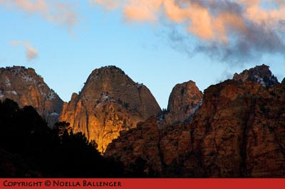
ZION NATIONAL PARK
Sunset was spectacular bathing the mountains in golden light.
Again, I consulted Bob Hitchman’s Photograph America to find the best photographic locations. We used one of his maps and concentrated our efforts in the southwestern section of Utah. Utah is one of the richest states in the country photographically, and I’ve traveled extensively there. (See Bob Hitchman’s Photography America at http://www.photographamerica.com and my articles for Apogee Photo at https://www.apogeephoto.com/mag3-6/mag3-8_utah.shtml and https://www.apogeephoto.com/mag4-6/mag4-6_utah.shtml). However, this trip I wanted to slow down and spend quality time exploring a limited area. Before planning my travel, I try to define what it is that I really want to explore visually. Utah’s landscape is spectacular in its beauty. My goal was to see if I could take what I found and make it really exciting.
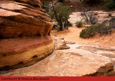
After spending the night in Hurricane, we were on our way to Cedar City and the first leg of our loop. The Kolab Canyons, at the northern end of Zion National Park, are finger canyons of rock which narrow into deep slot canyons. (If you’re hiking, be sure to check conditions at the ranger station.) The steep red-rock walls and deep green trees can be seen and photographed from the end of the road overlook. The graphics of those walls intrigued me. The colors of the rock seemed to pop out, because it was a really gray day, the beginning of our second round of late spring storms. We were delighted at the prospect of snow and rain.
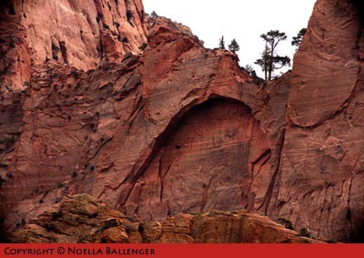
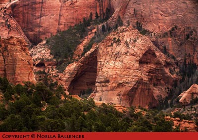
The Kolab Canyons of Zion National Park are remarkable in size. They stretch out like fingers and work back into small slit canyons. There are hanging valleys and potential arches carved into the uplifted red rock by the forces of wind and water.
Photos: An arch in the making at Kolab Canyons.
Unusual formations in the rock are testimony to the
forces of wind and water.
From Cedar City, we wanted to go to Cedar Breaks National Monument. Cedar Breaks is small area that’s similar to Bryce Canyon–with beautiful rock spires and formations. The road past Cedar Breaks to the small town Panguitch is a nice drive, but it closes during the winter and doesn’t re-open until snow plows can clear the roads (usually after Memorial Day). So we stayed on Route 14, crossing the mountains over a 10,000 ft pass and moving on to Bryce Canyon National Park, our destination for the next couple of days.
Not too far before we entered Bryce Canyon on Highway 12, we discovered a small area called Red Canyon. I have honestly never seen such brilliant red rock. My companions were all excellent photographers, so we invented a “game” in which we would drive only a short distance until one of us would yell “Stop!” Then we would all hop out to photograph something we had seen. Red Canyon gave us many photographic opportunities right from the road. To complement what we were seeing, we stopped at the new Visitor Center and found many interesting books as well as a good interpretive area. Spending time in visitor centers is a great idea, because if the rangers aren’t too busy, they’ll frequently take a few moments to tell you about their favorite locations.
On the way to Utah’s Bryce Canyon National Park, the Red Canyon has perhaps the most colorful, vivid red rock formations. There are some fascinating shots that can be taken right from the road.
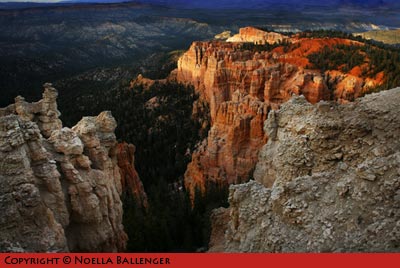
Photos: Low light coming in under the heavy clouds at sunset was spectacular on the formations of Bryce Canyon.
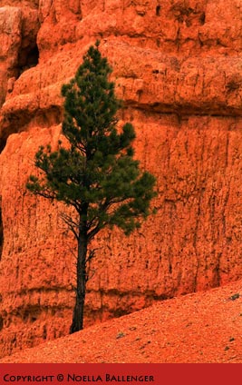
A lone green tree against the rough face of rock is a study in pattern and texture at Red Canyon.
Even though the hour was growing late, we decided to go into Bryce Canyon National Park and check out locations for sunrise. Bryce Canyon is set up well for visitors. There is one main road that goes about twenty miles into the park, and off of this road are small pull-out loops that lead to overviews of the canyon. Each pull-out area has something special to offer. We went to the end of the road to enjoy sunset. The weather was cold and windy, but the color on the clouds and the slashes of light illuminating the red and orange rocks were stunning. We planned an early morning for the next day, because we suspected the sunrise would be equally spectacular.
The next morning, we were up early. Just as we entered the park, a few snowflakes began to hit our window. By the time we reached Sunrise Point, the snow was coming down hard. We decided to walk from the parking area to the overlook, anyway—just in case we would be able to see. But there was nothing to see but white, white, white. Time for a group photo.
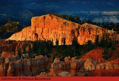
BRYCE CANYON NATIONAL PARK
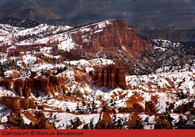
Snow capping the formations in Bryce Canyon only make the rocks seem more vivid in color.
After breakfast, we returned to the overlook. This time, we could see a lot more. In fact, the day promised to be breathtaking. The clouds were beginning to break up, and patches of blue were starting to appear. The red rocks peeked out from under a covering of white. Since the snow covering was relatively light, it quickly began to disappear. It’s important to seize such wonderful opportunities and work fast but thoughtfully.
A little later, we drove to another favorite small park not far from Bryce Canyon. Colorful Kodachrome Basin State Park is located to the east of Bryce Canyon and not too far south of Henryville on State Route 12. We drove around the park and found the parking location for Shakespeare Arch, which was a twenty minute walk away. This small but beautiful arch was first discovered in the late 1980’s by one of the park rangers and named after him. By the time we returned to Bryce Canyon, we had just enough time to continue our explorations of Bryce Canyon at sunset.
KODACHROME BASIN
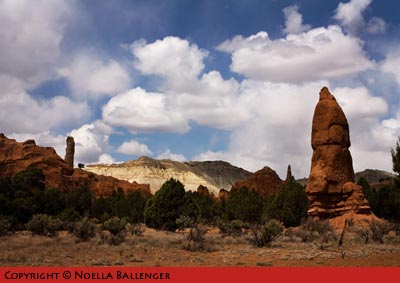
This small park has many spires and unusual formations.
The next day, we left Bryce Canyon and backtracked to Cedar City, once more crossing the high mountains but this time in a snow storm. The snow turned the trees and rocks into a fairyland. We were on our way to an entirely new adventure.
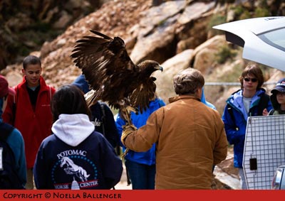
A few years ago while I was on a Triple D Animal Workshop, I met a wildlife rehabilitator named Martin Tyner (https://www.apogeephoto.com/july2001/nballenger1_72001.shtml). He rehabilitates wildlife for release whenever possible. As a part of the Triple D workshop, he was working with several birds but I was really impressed with a golden eagle named Bud. I have always loved birds, but it’s rare to see large raptors up close. I had heard that Martin had been given some land near Cedar City for his Southwest Wildlife Foundation, and I wanted to see it. So, while we were in Bryce Canyon, I contacted him, and we received an invitation to join him as he spoke to a group of school children from Washington, DC.
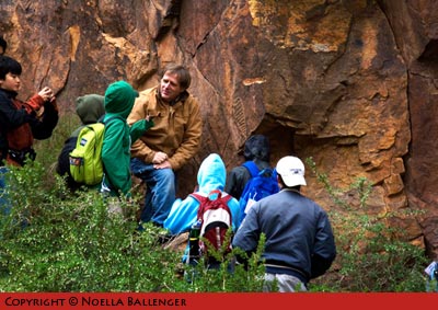
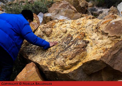
We had a wonderful time watching Martin show these schoolchildren petroglyphs, dinosaur footprints, and Scout, his new eagle. The children posed great questions and gained new understanding of the geology of the area, the early people who lived there, and the birds. (Check out Martin’s website at http://www.gowildlife.org and be sure to watch the video they did with their new eagle, Scout (http://www.current.tv/studio/media/5791598).

Martin Tyner with Golden Eagle Scout.
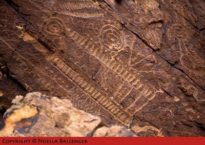
Martin Tyner showing the children the petroglyphs near Cedar City, Utah. He spoke about the way they were made and the early people who lived in the area hundreds of years ago.
That night, we ended up back in Hurricane to plan our next day. We decided to travel in a big circle, going from Hurricane to Pipe Spring National Monument through Kanab to Coral Pink Sands and then on into Zion National Park via the eastern route. Our final destination for the evening would be Springdale, Utah. Pipe Spring National Monument is a small gem of a park. Because of the spring located there and the abundance of water, it has been a popular destination for American Indians, early settlers, and Mormon pioneers. It’s a great place to learn about the people who inhabited the area.
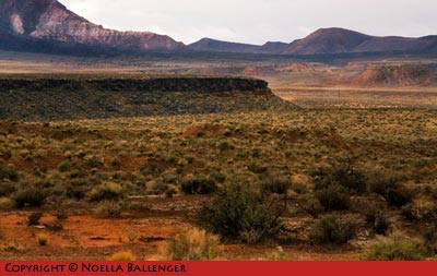
PIPE SPRING NATIONAL MONUMENT
A beautiful view of the area as we traveled toward Pipe Spring National Monument
Farther along, Coral Pink Sand Dunes State Park is a lovely area of bright pink-and-red sand dunes. During certain hours of the day, dune buggies go racing around, but at sunset or sunrise, the park falls quiet. The dunes shift in color from white under the glaring sun to soft, lovely rich hues as the day wanes. (Look for small animal tracks on the fringes of the dunes.)
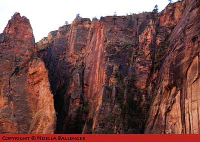
We had been chased by the storm all day, and as we entered Zion National Park late that afternoon, we could see the rain and snow at the tops of the mountains was beginning to break up. We entered the park from the east, going through a long tunnel and then down a series of switchbacks until we reached the river. When we arrived at the second switchback, all of us yelled, “Stop!” We leaped from the car, running to get into position as the clouds opened and streaks of sunlight began to hit the distant mountains. It was a fabulous sunset with red cliffs, green trees, and waterfalls that occur only when it rains. We barely made it to dinner before many of the restaurants closed.
We were up for sunrise and hurried back through the tunnel to some areas we had seen when we were coming into the park from the east. The striation of the rock layers spoke to us of the beautiful sand dunes that were here ages ago. Those dunes were solidified by minerals, slowly compressed, uplifted, and worn away. What’s left inspires you to pick up a geology book to discover how those wonderful mountains were created and what forces of nature are still working there.
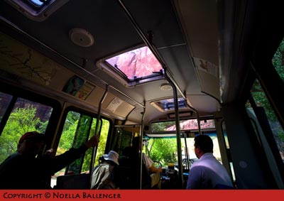
Zion is an exceptional park, and the National Park Service has found a way to allow many visitors into the park and still keep the burden of traffic to a minimum. They run a bus shuttle from the visitor center near Springdale to the end of the road. Shuttles come and go about every ten to twelve minutes. The shuttles are free (after you pay the general park entrance fee), and you can get on or off at any of a number of stops. This makes travel very convenient and Zion a “no-hassle” park.
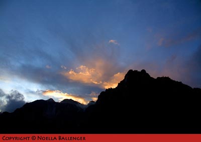
ZION NATIONAL PARK
Clouds were just breaking up after a storm and the cliffs were wet and vivid in color.
As the clouds broke up, the sky began to glow. The longer we waited the better the sunset looked.
We took the shuttle to the end of the road, and my friends went off to walk further upstream to the “Narrows,” an area where the Virgin River cuts through a narrow canyon. I wanted to stay near the river and work with a camera that I had converted to infra-red. Infra-red is relatively new for me. It’s a new way of seeing and working. I tell my workshop participants that learning and playing with new ideas or concepts will eventually cause wonderful creative juices to flow. And isn’t that what photography is all about? So, while my friends walked, I played and had a marvelous time!
The next day was another early shoot, but it wasn’t quite as spectacular as the previous day. I guess we were getting spoiled. After breakfast, we were dragging our feet, headed for home. As we traveled, we reflected on our two great weeks of travel. It’s wonderful to be with people you care about and with whom you share a love of photography. Certainly the scenery in both Death Valley and Southern Utah is spectacular, and our weather was fantastic. There’s nothing like having Mother Nature work with you, although being up early, out late, and working very hard helps you catch wonderful images.
If you’re traveling to southwestern Utah, check out these websites for general park information: If you have any questions, drop me a note at noella1b@aol.com.
Bryce Canyon NP – http://www.nps.gov/brca/historyculture/index.htm
Cedar Breaks National Monument- http://aolsearch.aol.com/aol/search?invocationType=topsearchbox.search&query=Cedar+breaks+nm
Coral Pink Sands State Park – http://www.americansouthwest.net/utah/coral_pink_sand_dunes/state_park.html
Kodachrome Basin State Park – http://www.americansouthwest.net/utah/kodachrome_basin/state_park.html
Pipe Springs National Monument – http://www.cr.nps.gov/history/online_books/glimpses2/glimpses24.htm
Red Canyon – http://www.americansouthwest.net/utah/red_canyon/index.html
Zion National Park – http://www.nps.gov/zion/

RED CANYON
Standing at the side of the road, we admired the brilliance of the red rocks.
RED CANYON
The different color of rocks only make the reds stand out more.
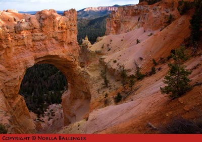
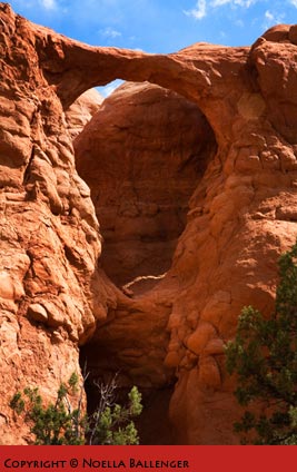
BRYCE CANYON NATIONAL PARK
A beautiful natural arch near the end of the road
BRYCE CANYON NATIONAL PARK
Low light coming in under the heavy clouds at sunset was spectacular on the formations of Bryce Canyon.
KODACHROME BASIN
The tiny Shakespear Arch is well worth the easy walk from the parking area.
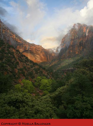
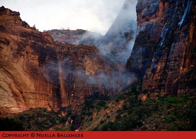
ZION NATIONAL PARK
It was late afternoon and the storm was just beginning to break up. We stopped at one of the overlooks on the west side of the tunnel. Note the waterfall that runs after a storm in the high country.

ZION NATIONAL PARK
On the east side of the park, sand dunes frozen in time are outstanding opportunities to photograph lines, shapes and patterns.
ZION NATIONAL PARK
On the east side of the park, sand dunes frozen in time are outstanding opportunities to photograph lines, shapes and patterns.
ZION NATIONAL PARK
We rode the bus along the Virgin River into a beautiful area of the park. The mountains are so high and so close; you can enjoy looking at them through the skylights in the bus.
ZION NATIONAL PARK
The mountains near the Narrows at the end of the bus ride. It was difficult to know what to photograph or what to look at first … there was just so much to see.
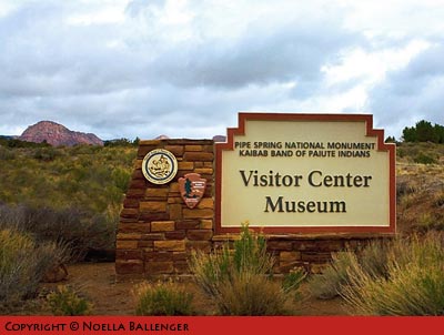
PIPE SPRING NATIONAL MONUMENT
Visitor Centers are a great place to begin an exploration of an area.
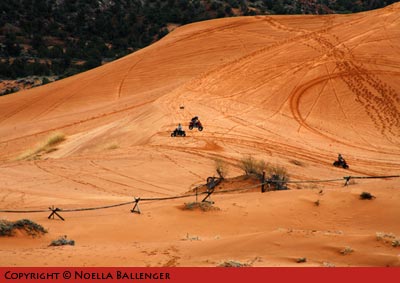
CORAL PINK SANDS STATE PARK
It is possible to walk out to the fence to observe the buggy activity close up.
WILDLIFE REHABILITATOR AND EDUCATOR
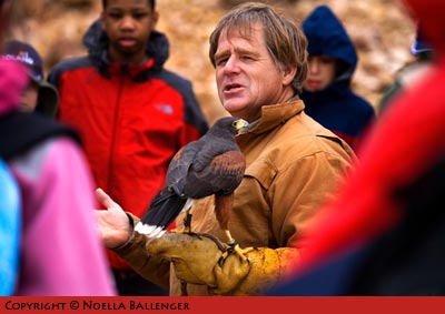
Martin Tyner showing his Harris Hawk to the group.
WILDLIFE REHABILITATOR AND EDUCATOR
Martin Tyner with his Golden Eagle, Bud. Bud is an eagle that is used in his education programs.
CEDAR CITY – SOUTHWEST WILDLIFE FOUNDATION
The petroglyphs are in outstanding in detail and preservation. It is estimated that these petroglyphs are between 500 and 1000 years old.
CEDAR CITY – SOUTHWEST WILDLIFE FOUNDATION
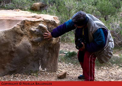
An impression of the paw of an ancient adult dinosaur is found in one of the boulders.
CEDAR CITY – SOUTHWEST WILDLIFE FOUNDATION
An impression of the paw of a baby dinosaur.
by Noella Ballenger
Leave a Reply