
© 2011 Robert Hitchman. All Rights Reserved.
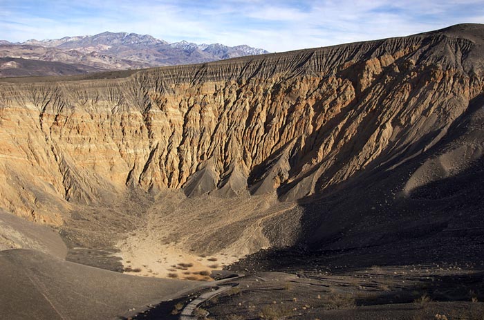
Ubehebe Crater
Nikon D300s| f/16 – 1/125 sec. | ISO200 | 24mm lens
A long, flat playa lies hidden at thirty-seven hundred feet in the Cottonwood Mountains, on the western side of Death Valley National Park in California. Get onto Hwy. 190 going east from California’s Hwy. 395 or going west from Nevada’s Hwy. 95. Bear north at Scotty’s Castle and follow the paved road toward Ubehebe Crater. It’s a sixty-mile roundtrip to the Racetrack, requiring a high-clearance four-wheel-drive vehicle. A marked side road to the Racetrack heads west. A sign warns of a slow and rough twenty-seven-mile road to the Racetrack.
© 2011 Robert Hitchman. All Rights Reserved.
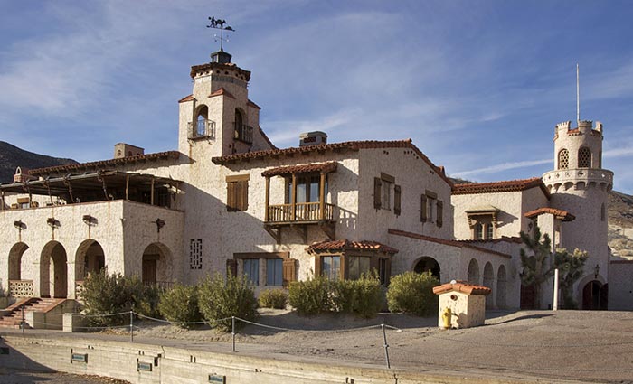
Scotty’s Castle
Nikon D300s| f/16 – 1/100 sec. | ISO200 | 24mm lens
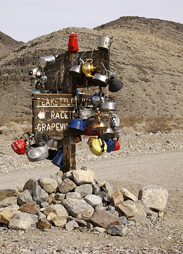
It’s a slow, steady, climb for the first twenty miles. Visitors driving this road stop at Teakettle Junction to photograph the direction sign, festooned with dozens of teakettles, left by travelers from all over the world. At the junction, keep to the right and continue driving west on the Racetrack Valley Road. You’ll soon see the ochre-colored playa (a dry lake bed) far off in the distance, seven miles south. From this spot the road heads downhill to the edge of the Racetrack, lying at an elevation of 3,708 feet.
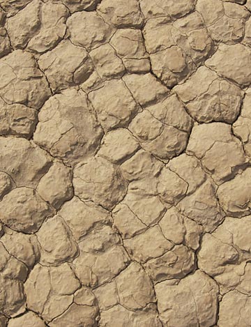
A sign on the edge of the playa requests that visitors stay off the crackled surface when it’s wet. Footprints can remain for many years in the surface and they spoil the photography. During a heavy rain, water collects on the flat playa and forms a shallow lake. As the water evaporates, what remains behind is a soft layer of mud. As the mud dries, it shrinks and cracks into an intricate pattern of interlocking polygons.
© 2011 Robert Hitchman. All Rights Reserved.
© 2011 Robert Hitchman. All Rights Reserved.
Above: Close-up of Racetrack
Nikon D300s| f/16 – 1/160 sec.
ISO200 | 24mm lens
Left: Teakettle Junction
Nikon D300s| f/16 – 1/80 sec.
ISO200 | 34mm lens
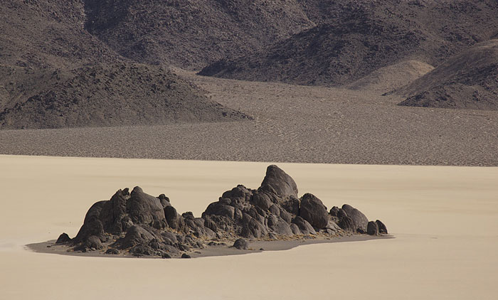
A large formation of black stones, called “the Grandstand,” rises from near the center of the playa at its north end. Park in the wide spot near the north end of the lakebed and walk from your car out onto the playa. A stroll around the formation, and back, will take a half-hour. Late in the day, dark shadows of these black rocks make fascinating patterns across the light-colored surface of the playa.
© 2011 Robert Hitchman. All rights reserved.
Grandstand on Racetrack
Nikon D300s| f/11 – 1/400 sec. | ISO200 | 120mm lens
A marked trail climbs up the slopes of Ubehebe Peak on the west side of the playa starting near the Grandstand viewing area. After climbing several hundred feet up the trail, you reach a point where the top of the Grandstand is no longer merging into the distant mountains. This higher camera angle makes a much better composition. This trail is gradually sloped and is worth the effort.
In the distance, you’ll see a few small rocks scattered across the surface. These are the famous “moving rocks.” During rare wet winters in this part of the high desert, the playa surface floods and freezes. Strong winds blowing up from the Saline Valley to the west or down from the north move rocks across the playa surface.
Drive two miles south and park at the only other wide spot along the road at the south end of the playa. Gather up your camera gear and both telephoto and wide-angle lenses, plus a tripod, and walk east from the road. Most visitors walk out a few hundred feet and return. Keep walking. It’s a mile to the largest concentration of small rocks and fifty-pound boulders of dolomite that are not visible from the road, over a mile away.
© 2011 Robert Hitchman. All rights reserved.
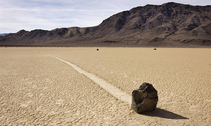
Sliding Rock
Nikon D300s| f/18 – 1/125 sec. | ISO200 | 24mm lens
© 2011 Bob Hitchman. All rights reserved.
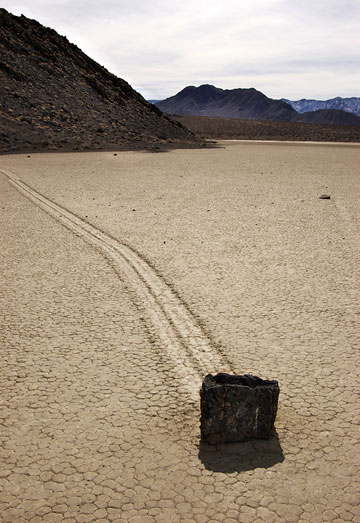
Sliding Rock
Nikon D300s| f/18 – 1/160 sec.
ISO200 | 24mm lens
You’ll find several hundred large and small rocks out on the playa. Most have created long, twisting trails in the mud. Some of the trails zigzag back and forth. Others loop across the surface in circles. Using GPS instruments, researchers have measured the longest trail at three thousand feet. There has never been a recorded sighting of rocks moving across the surface of this playa. Perhaps the ninety-mile-per-hour winds and freezing temperatures have kept observers away when it’s happening.
Use a wide-angle lens to frame vertical compositions with a stone in the foreground. The trail stretching off into the distance is usually the most effective way to document these traveling stones. Early morning and late afternoon light cast long shadows and show the texture of the tiny polygons covering the Racetrack. S ome impressive tracks lead to stones far out in the center of the playa where crosswinds have created erratic tracks.
Leave the Racetrack the same way you came in while there is enough light in the sky to follow the road out. If you want to stay overnight to photograph a sunset and sunrise across the Racetrack, spend the night at the Homestake Dry Camp.
It can be extremely hot from May through September, so you may want to explore the area in the fall or winter.
You won’t want to miss this interesting area of Death Valley National Park.
by Robert Hitchman, Photograph America
Text and photos: © 2011 Robert Hitchman. All Rights Reserved.
Leave a Reply