
In Part 1 of this story, we left Salt Lake City driving through the San Rafael Swell and San Rafael Reef to the town of Moab. Using Moab as our headquarters we visited Canyonlands National Park, Arches National Park, several state parks and the La Sal Mountain Loop road. At Blanding, a decision needs to be made. If you are short of time, return to Salt Lake via Natural Bridges National Monument. If you have the time, stay with us … we think you will enjoy the ride.
 Time permitting, from Blanding, continue south on Highway 191 and 163 through Mexican Hat to Monument Valley Navajo Tribal Park. There are camping and RV facilities in the park. In Gouldings, adjacent to the park, there is a motel, store and gas station. The massive rock formations in Monument Valley are some of the most photographed geographic features in America. As you turn into the park from the highway, local native artists sell their crafts from small stands at the roadside. They offer a variety of jewelry, woven goods and food. We can highly recommend the delicious fry bread and Indian tacos. If you haven’t ever tasted them, you are in for a treat. It is possible to drive the dirt road on the valley floor and walk to the base of several formations. Or, take a Navaho-guided tour and save the springs of your car. Whenever you are on any reservation land, ask before you photograph homes or people. It is only the polite thing to do. A monetary compensation may be requested, but remember, this is part of their livelihood and should be respected.
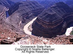
The turnoff for Goosenecks of the San Juan State Park is north of Monument Valley and Mexican Hat on State Route 261. (This can be treated as a side-trip excursion from Gouldings or can be visited as you leave the area and travel to Torrey.) The drive across a relatively flat, unchanging mesa makes this stop even more spectacular as you look down 1000 feet to the San Juan River. In one mile, as the crow flies, the river travels over six miles, winding its way and creating narrow mesas. One of the mesas, at its narrowest point, is less than 100 feet wide. There are interpretive signs, a hiking trail, camping and day-use picnic sites. Firewood and water are not available. Be prepared!
Leaving the Goosenecks, continue north on Highway 261. You will see a mesa directly in front of you and wonder – almost until the very last minute – if the road dead ends. Then you will see the climb up the Moki Dugway. The highway turns to graded gravel and, in several short hairpin turns, begins to climb straight up the mesa face. Drive it carefully to enjoy the views. Once on tip, take the graded dirt road to the west for a side trip to Muley Point Overlook. Breathtaking views of the Gooseneck area are at your feet, Valley of the Gods to the east, the Rapple Anticline (locally known as the Navajo Blanket because of its design and colors) to the south, and Monument Valley to the southwest. Sunset and dawn dramatically change the appearance of the land.
At the top of the Moki Dugway you are on Cedar Mesa. This elevated land, fairly level and wooded, is the setting for Natural Bridges National Monument. Here intermittent streams have cared the bridges that are tucked into the arms of the canyons. Where arches are formed by weathering/salt action, bridges develop as running water undermines a “gooseneck,” and leaves a bridge spanning the new cut. Pick up the self-guided tour brochure at the visitor center and drive the one-way loop road. The wheelchair accessible overlooks are also the trailheads for walking into the area as time and energy permit. Being able to photograph the natural bridges from above as well as below is well worth the effort. An additional very interesting feature of the park is the world’s largest solar photovoltaic system. Sunlight is used to produce all of the electricity for the monument’s needs.
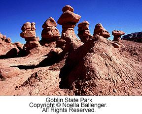 From Natural Bridges, continue north and cross an arm of Lake Powell in the Glen Canyon Recreation Area. Highway 96, the Bicentennial Highway, crosses the Dirty Devil River and the Colorado River as it comes out of Cataract Canyon in Canyonlands. There are rest areas available for picnicking or take the short road to Hite for camping facilities. From the river crossings to Hanksville is a beautiful drive that take you back into the sandy, high-desert plateau. About 20 miles north of Hanksville is the turnoff to the Goblin Valley State Park. Part of this road is paved and part is graded gravel. Goblin Valley is a park of unusual formations and one where your imagination (and camera) can run wild.
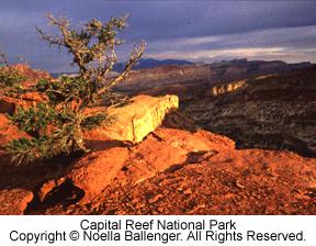
After Goblins, return to Hanksville and journey west on Highway 24 to Capital Reef National Park. Torrey, on the western edge of the park, can be used as another trip-headquarters area.. As in so many of the parks in the plateau, full access is limited to Jeep trails, hiking or horses, but what you do see from the road and overviews is quite special. Capital Reef lies primarily within a massive geologic structure called the Waterpocket Fold. From the air, the formations of the Waterpocket Fold bear witness to the massive pressures of twisting, fracturing and weathering that have sculptured t he region. At the Old Fruita School House, sheer canyon walls loom overhead. Look for pictographs and petroglyphs on the walls. There are fruit trees that were planted many years ago by early Norman settlers. These orchards are still worked and deer are frequently seen in the area.
Pick up State Route 12, a beautiful scenic highway that winds through the Boulder Mountain area. High aspen forests and pine trees line the road. There are several campsites at the higher elevations. Bowns Reservoir has boating and fishing facilities. In the fall, this road is a vision of brilliant orange and gold. You may be forced to take your time here, as occasionally cattle are driven down the center of the road.
In the late 1950’s the University of Utah began excavation of a major archeological site in the town of Boulder. The result is the Anasazi Village State Park. There is a museum, and the excavation site has been reconstructed to show parts of the village as it once existed. There were more people living in the Anasazi village 900 years ago than live in Boulder today. The day of our visit, one of the park interpreters gave an exhibit of fire-starting techniques. Be sure to call ahead to inquire about any special programs that might coincide with your visit to this fascinating site.
 Still on Highway 12, continue west as the road stretches along a hogback before dropping into a canyon and climbing out again. Stop at Kodachrome Basin State Park which was named by the National Geographic Society during a filming episode in the late 1940’s. Steep knife-edged ridges and spire formations are the highlights. It also boasts of the most recently discovered arch in Utah. Stay for sunset. If you are camping, there is a campground in the heart of the formations. Limited spaces, no reservations.
Continue to Bryce Canyon National Park. This park, very popular both in the summer and winter months, is a gem. Although access can be difficult in the winter, the park is open and the major roads are maintained. Motels are open year-round, but call about off-season camping accommodation. Bryce Canyon is a series of amphitheater cut into the edge of the Paunsaugunt Plateau. Erosion has carved these areas, leaving brilliant orange, pink and white spires. Paved walkways and railed fences allow visitors to walk, view and photograph these magnificent bowls from above. Hikers can take a more active approach and enjoy the many trails that wind among the spires.
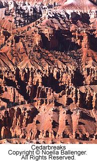
Leave the park and travel west. Join Route 89 and drive north to the town of Panguitch. Turn south again on State Highway 143 to Cedar Breaks National Monument and the Brianhead ski area. The drive into the monument the “back way” goes through rolling hills, narrow valleys, aspen groves, alpine meadows and lava flows. As the air thins and the wind develops a bite, you realize you have entered the highest of the plateau parks at an altitude approaching 10,000 feet. Again, overlooks bring you to the edge of the formations, where sweeping vistas show the artful work of wind and water. Return to Highway 89 by traveling east on Route 14. Along the way, stop at Navajo Lake. There are good picnic spots and always fishermen to watch.
 Rejoin Highway 89 and turn south toward Mt Carmel Junction. The next small park to visit is Coral Pink Sand Dunes State Park. The turnoff is not well marked, but will be the first road to the right, approximately 3 ½ miles south of Mt. Carmel Junction. The park itself is about nine miles from the highway through a narrow valley of pinon pines and sage. The tall sand dunes are “trapped”” in valley bowl, and have been eroded from the adjacent coral-colored cliffs. The sands are at their best in early-morning and late-afternoon light. There are no accommodations other than camping and RV sites. The area is open to ATV riders.
Return to Mt. Carmel Junction and travel west on Highway 9 to Zion National Park. After entering the park, the road follows Clear Creek through Navaho sandstone slickrock formations. The striations in the rock make wonderful pattern-and-texture shots. There is a mile-long tunnel that takes you from the highlands into the canyons of Zion. As you drive the tunnel slowly, have the passenger prepared. There are several arched-view openings. No stopping is allowed in the tunnel. However, if you drive cautiously and your timing’s right, an unusually framed photograph is available. As you leave the tunnel, stop at the overlook and enjoy the vistas. Six switchbacks descend into the canyon, and each turn offers a different view. On the road past Zion Lodge, one of the most interesting sights is Weeping Rock, where water seeps in small drops out of the face of a cliff. Return to Highway 9, exit the park to the west and rejoin Interstate 15 to Salt Lake City.
As you leave the area, there is one more road that should be taken. Just off Interstate 15, in the northern section of Zion National Park, are the Finger Canyons of the Kolob. Sunset is the best time in this west-facing section of the park. As you drive in, narrow river channels carved out of rock begin to blaze in the setting sun. At the end of the road is an overlook and a place to sit and ponder the sights that ;you have seen in this magnificent corner of America.
More Tips:
Photography in the southwest can be tricky. There is lots of reflected light from one surface to another.
Consider using a half-neutral density filter to balance light. If the rocks seem too bright, consider turning the filter to tone those down. Also, a polarizer can make a difference too. Don’t over-do the filter effect as the photograph should look “natural” and black skies don’t look natural.
During the spring and fall, the light is mellow and comes from lower in the horizon. Morning and evening light is especially good. During the middle of the day, scout your locations, try some macro photography. There are all sorts of “critters” in the desert areas as well as special weeds and flowers.
Also concentrate on being selective in your compositions. Think about lines and shapes and design. Interpret the location by magnificent scenics but then capture the essence of the area. Think in terms of minimums … how little can you show in a photograph and still have it say Monument Valley? Use your imagination and remember the essence of the desert can be found in its subtle details.
Travel Tips (From Part 1)
- Utah’s Travel Council has a variety of general materials available on travel in Utah. Utah Travel Council, Council Hall/Capital Hill, Salt Lake City, UT 84114
- Utah publishes an outstanding set of sectional maps. For this trip, ask for the Utah Southwest Section Map and the Utah Southeast section Map.
- Contact the Bureau of Land Management (BLM) for information on the lands not included in many parks. Bureau of Land Management, Salt Lake City Office, 324 South State Street, Salt Lake City, UT 84111.
- For those interested in jeep trails, there is a series of books available called Off-Road Vehicle Trails. They cover various sections of Canyonlands, Arches, and La Sals areas. Maps are also available at ranger headquarters in the various areas.
- There are many dirt roads that are passable under certain weather conditions for two-wheel-drive vehicles. Where assistance could be difficult to obtain, it pays to be prepared. In desert areas, this means carrying plenty of water, food and occasionally, fuel. A spare tire and minimum tools (and a knowledge of how to use them) can be helpful. Always let someone know where you are going and when you think you will be returning. Then be sure to let them know when you have returned.
by Noella Ballenger & Jalien Tulley
Leave a Reply