
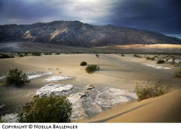
The effects of light and dark as the sun streaks
across the sand dunes is breathtaking.
This past April, I tacked a really wonderful stay in Utah onto the end of my Death Valley workshop. The first order of business for planning any trip is to get a good map and equally good information. I always turn to Bob Hitchman’s Photograph America (www.photographamerica.com). Bob has the best tips on where to go, how to get there, and the ideal times for photography. (Click here to see one of Bob’s maps of Death Valley.)
After leaving Los Angeles, our group spent our first night in Bishop, California, a small town on the eastern side of the Sierra Nevada mountain range. Although this destination was a detour, I wanted my friends to see the Mountain Light Gallery. The late Galen Rowell’s work is absolutely beautiful, and a visit to his gallery is well worth going out of your way. There is nothing like being inspired by beautiful photography as a trip begins. (The gallery website is http://www.mountainlight.com.)
Leaving Bishop, we back-tracked to the town of Big Pine and then experienced a surprising light snow storm as we crossed Westgard Pass, which separates the White Mountains from the Inyo Mountains. The Death Valley workshop is one that I normally decide to conduct earlier in the year. Death Valley in February or March is delightful–warm days and cool nights. The sun is low on the horizon and the light is soft. As spring turns into summer, however, the light in Death Valley becomes harsh, and the heat can be debilitating. So, we were thrilled to see clouds and snow. All photographers know that bad weather can be wonderful for images. The light comes soft or hard; clouds can be dark and awesome, fluffy and white, or any type in-between. To our delight, we enjoyed a couple of late spring storms.
I’ve found that Stovepipe Wells in the middle of the valley is the most convenient place to hold my workshop. The motel tends to be on the rustic side but remains very adequate. Some remodeling was done in the last year or so, and it has made a big difference.
Artist’s Point in the southern end of Death Valley presents a colorful display of minerals.
Our first photographic challenge in Death Valley is always the sand dunes. They’re just a couple of miles down the road from Stovepipe, which makes a pre-dawn journey easier. The ideal time to go out on the dunes is before first light. The best hint I can offer about getting back to the larger sand dunes is for you to take a flashlight and walk in from an angle for about 3/4 mile until you see the sign on the road that says “Sand Dunes.” It’s a lot easier to climb one sand dune on a ridge than to try to walk straight in going up and down over each of the smaller dunes.
For our group, first light on the dunes was quiet, but then magic started to happen. The cloud cover was breaking up and the possibilities were endless. As we moved into position, I suggested everyone think about lines and light and start to plan shots. Subtle shifts in light come quickly, and the wise photographer will be prepared, staying alert to what’s happening in every direction. The time for really dramatic light is short, so we had to anticipate some shots and then be on our toes and ready to meet the unexpected. And unexpected it was. We were treated to a brilliant light show for dawn–one of the best I can remember seeing on any workshop. It was exhilarating and exhausting at the same time.
After breakfast, we went to see my other favorite Death Valley locations in the northern and middle sections of the valley. They include the following:
Scotty’s Castle in the northern part of the valley is an historic home of elegant proportions. Death Valley Scotty is one of the great legends in Death Valley. The castle was built in the 1920’s and is worth visiting. (Tours fill up quickly, so go early.) Also, if you have the time, take the underground tour of the castle. I found it fascinating.
Ubehebe Crater, near Scotty’s Castle, is a lesson in volcanic geology. About 2,000 years ago, hot magma came up through a crack in the earth’s surface, met wet alluvial fan material, and a violent steam explosion blasted through the rock, creating the crater.
Titus Canyon is a 26-mile, one-way jeep road coming from near the town of Rhyolite, Nevada, west into the valley. While the drive is beautiful, it’s long and can be closed due to flooding. However, the road is two-way on the valley side. You can drive to the mouth of the canyon and walk in. It’s a narrow canyon at the west end, and the steep walls provide an interesting insight into the geology of the valley.
Salt Creek Canyon – Sunset is my favorite time here. The little stream that runs through the area and disappears into the desert floor is the home of tiny Salt Creek Pupfish, an endangered species. They can usually be seen in March and April and are descendants of fish from prehistoric times that swam in the lake that once occupied the floor of Death Valley. They are only an inch or so in length.
Mosaic Canyon – The road to this small canyon is just west of Stovepipe Wells. It’s a short walk into the canyon, but as the passage narrows to about four feet in width, you have the feeling of being in a slot canyon. This marble canyon was carved by water, and you certainly wouldn’t want to be there in a rain storm. Note the beautiful grain of the marble and its coolness on even the warmest days.
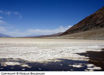
Badwater, at 284 feet below sea level, is the lowest
point in the United States.
One evening we were photographing sunset at the Devil’s Cornfield, an area near the dunes where the wind has ripped the ground away around clumps of plants, exposing their roots. Long shadows turn an “ordinary” landscape into something quite unusual. The air was calm when we stopped, but the wind came up suddenly and very hard. Quickly bundling our camera gear, we dashed to the cars and returned to the motel. We spent the evening checking and cleaning our cameras. (Sand blows in even a mild wind, and you need to be very careful of fine sand particles.)
The wind continued to blow hard all night, but we decided we were too tough to be discouraged and set off early to make first light at Zabriskie. The wind had settled somewhat by the time we arrived, but it picked up once again just as the sun was rising. Camera gear aside, blowing sand can be a real hazard for anyone who has even a mild tendency toward breathing disorders. It’s always a good idea to be prepared with a scarf or a mask to don when the sand is blowing. However the light, wind, and even the sand created wonderful photographic opportunities for us.
The famous Furnace Creek Inn and Furnace Creek Ranch lie in the southern section of the valley. Both are interesting places to stay. The Inn is an old, upscale resort and it’s lovely. The Ranch is more relaxed and similar to a quality motel resort. When my group is doing a dawn shoot at Zabriskie Point, we always plan for breakfast at the Ranch coffee shop–something to look forward to when we have to get up so early.
After the dawn shoot at Zabriskie Point and breakfast at Furnace Creek Ranch, I like to drive into the southern area of the valley. Some of my favorite places in this section are:
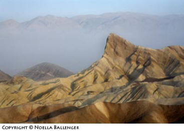
Zabriskie Point is an excellent location for a dawn shoot. The day we were there you could see the sand being blown about in valley making visibility quite hazy.
Zabriskie Point is definitely a dawn shoot which lies about 40 miles from the motel at Stovepipe, so plan your driving time accordingly. It’s a lovely overlook with colorful hills in the foreground and salt plains and the Panamint Range as a backdrop. The hills in the foreground make especially graphic images with their lines, colors, and textures.
Badwater – At 283 feet below sea level, Badwater is the lowest point in the United States. A perpetual spring gives the small, shallow pool its name, because the water is extremely alkaline and bitter. It’s possible to walk out toward the center of the valley to see some of the salt pans.
Natural Bridge (which is precisely what its name implies) hovers over one of the easily-explored side canyons. You need to walk into the canyon along a pebble floor for about 15 minutes to reach the bridge.
Devils Golf Course is an area where you can see the salt crust in the valley. Between 2,000 and 4,000 years ago, Devil’s Golf Course was a lake that measured about 30 feet deep. When the lake dried up, it left a salt crust that looks churned. Close examination reveals tiny salt crystals that are really lovely.
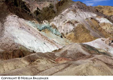
Artist Palette is one of the loveliest little drives in the park. You go up and down through ravines cut in an alluvial fan. The colors of the rock are a result of a variety of minerals. Artist Palette is wonderful in the late afternoon and on an overcast day when the colors just jump out at you.
West Road is a dirt road that runs down the west side of the valley. To get images that show the isolation and desolation of the valley, take the road for a short distance and use wide-angle lenses to emphasize that perspective. You can catch a different view of the valley by driving all of this long dirt road, but unless you have extra time, I don’t recommend it. By the time we finished exploring the southern end of the valley, we had put in a full day and were content to head back to Stovepipe Wells for a relaxing evening and dinner.
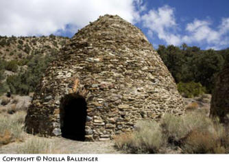
The charcoal made in these kilns allowed the miners in this area to smelt the ores they extracted from the mines.
If you have additional time in the valley, other interesting side trips include these:
Wildrose Charcoal Kilns were built in 1877 by George Hearst to make charcoal that was used to fuel silver-lead smelters for the ore from his mines in the Argus Range (about 25 miles to the west). The kilns were in use for about a year, and the camp of Wildrose had a population of about 100 people. The kilns are a beautiful example of what was once an essential part of mining operations. They’re in pristine condition and are definitely worth the time.
Aguereberry Point – If you like dirt roads, traveling to Aguereberry Point is almost as much fun as the spectacular view. Look for wildflowers along the roadside. Stop at Pete Aguereberry’s mine, which will give you an idea of how rough life was for miners in these mountains. Continue on to the top of the point to enjoy a breathtaking vista.
When our workshop was just about over, I asked the group members to name their favorite place. We had a few variations, but everyone seemed to like the dawn shoot at the sand dunes best and a strong runner-up was the Charcoal Kilns and Aguereberry Point.
If you love the idea of a winter vacation, now is the time to plan your trip to Death Valley. The motels fill quickly during the winter and spring prime season. It’s an easy drive from Las Vegas, Nevada (about 2 hours). Besides Photograph America, another website to use to find more information about Death Valley is http://www.death.valley.national-park.com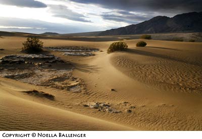
First light on the Sand Dunes promises a
beautiful sunrise.
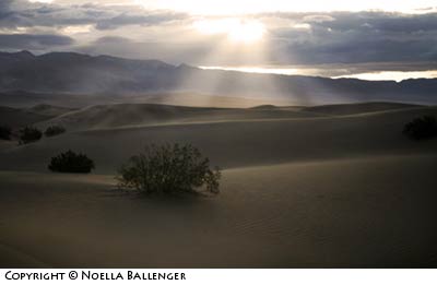
Shafts of light break through a hole in the cloud as we wait
for sunrise.
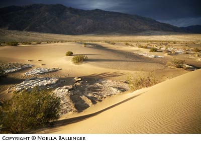
The end of the unexpected spring storm left remnants of dark clouds in the west making the first light on the dunes even more impressive.
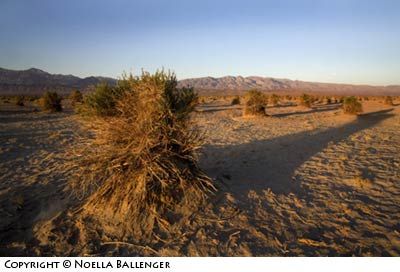
These are unique plants whose roots have been exposed by wind blowing the sand away. Beautiful in the last light of the day but within a minute of taking this photograph, the wind began to blow hard and we made a dash back to the cars and out of the blowing sand.
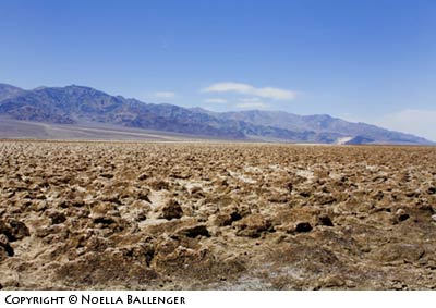
The Devil’s golf course is an area in the central part of the valley that is churned salt and dirt. It can be very treacherous to walk on.
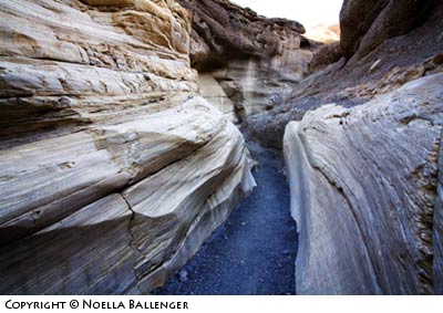
Mosaic Canyon has beautiful marble walls and is well worth the visit.
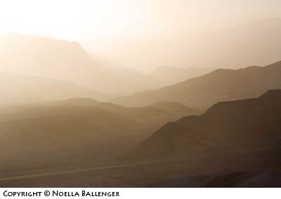
Just after the sun crested the mountains at Zabriskie Point, I turned around and realized how much sand was in the air. The road and telephone poles are not far from where we were standing.
by Noella Ballenger
Leave a Reply